ABOUT BALOCHISTAN
Balochistan is the province of Pakistan, forming the southwestern region of the country. It is Pakistan’s largest province by space, constituting a quarter mile of Pakistan’s total land mass. Its city and largest town is Quetta. It has borders with Punjab and the Federally Administered tribal Areas to the northeast, Sindh to the east and southeast, the Arabian Sea to the south, Islamic Republic of Iran to the west and Afghanistan to the north and northwest.
The main ethnic groups within the province are the Baloch individuals and the Pashtuns, The name Balochistan means “the land of the Baloch” in several regional languages. Mostly underdeveloped, its provincial economy is dominated by natural resources, particularly its natural gas fields, estimated to have decent capacity to supply Pakistan’s demands over the medium to long term. Apart from Quetta, a further area of major economic importance is Gwadar Port on the Arabian Sea.
Balochistan is wealthy in exhaustible and renewable resources; it is the second major provider of natural gas in Pakistan.
The province’s renewable and human resource potential has not been consistently measured or exploited due to pressures from within and without Pakistan. Local inhabitants have chosen to live in towns and have relied on sustainable water sources for thousands of years.
The climate of the higher highlands is characterized by terribly cold winters and hot summers. Within the lower highlands, winters vary from very cold in northern districts Ziarat, Quetta, Kalat, Muslim Baagh and Khanozai to milder conditions closer to the Makran coast. Winters are mild on the plains, with temperature never falling below freezing point. Summers are hot and dry, particularly within the arid zones of Chagai and Kharan districts. The desert climate is characterized by hot and extremely arid conditions. Often, strong windstorms make these areas terribly inhospitable.
Several major development projects, together with the development of a new deep sea port at the strategically important town of Gwadar, are ongoing in Balochistan. The port is projected to be the hub of an energy and trade passageway to and from China and the Central Asian republics. The Mirani Dam on the Dasht river, fifty kilometres west of Turbat within the Makran Division, is being built to supply water to expand agricultural land use by 35,000 km2 where it would otherwise be unsustainable. One of the world’s largest ship breaking yards is found on the coast.
The economy of Balochistan is largely based upon the production of natural gas, coal and other minerals.
[divider style=”normal” top=”20″ bottom=”20″]
PLACES OF INTEREST
[toggle title=”ASTOLA ISLAND” state=”close”]
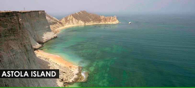
Astola Island is situated in Balochistan Province of Pakistan. It is also known as ‘Jezira Haft Talar’ or ‘Island of the seven Hills. It is an uninhabited island in the Arabian Sea. The Island is a part of Pasni sub-district of Gwadar District.
The island is 6.7 kilometres in length and a maximum width of 2.3 kilometres. The highest point of the island is 246 feet above sea level. Astola Island maintains endemic life because of its isolated location. It is a very important area for endemic life. It is also support a large number of breeding water birds and many other creatures. There is no source of fresh water on the island. That is the reason that there are no trees on the island. The vegetation depends on the occasional rainfall and soil moisture for survival.
In the Astola Island there is a small mosque associated with Khawaja Khizr and there are ruins of an ancient Hindi temple of Hindu goddess ‘Kali’. The island was called Satadip among Hindus.
Astola is a popular but hard destination for tourism due to the lack of lodging facilities. Tourists who are willing to stay overnight must bring their own provisions and camp on the island. Scuba diving, fishing and camping expeditions are popular.[/toggle]
[toggle title=”GWADAR” state=”close”]
Gwadar city, renowned for the warm water deep sea port of Gwadar, is found on the south-western Arabian Sea shore in coastal area of Balochistan, Pakistan. It is located about 460 kilometers from the city of Karachi and seventy five kilometers from Iranian border. It is the capital of Gwadar District. It additionally works as winter capital for the province of Balochistan.
For many years, Gwadar remained under the rule of many colonial and regional states, one after another. It came under the administrative management of government of Islamic Republic of Pakistan in 1958.
The port of Gwadar was finished in year 2007. it is located at the mouth of Gulf of Oman and at the apex of the Arabian Sea, which give it a great strategic importance. The depth of port is forty seven feet. It is used to handle massive consignment ships to Islamic Republic of Pakistan. The harbor is growing as main center of trade and a way for Oil imports of China.
The city of Gwadar was developed with a metropolitan master plan from scratch. It absolutely was used to be a village of fishermen before the development of Port. Gwadar is currently counted among a few planned cities of Islamic Republic of Pakistan.
Gwadar contains a hot desert climate, defined by very little precipitation and high variation between summer and winter temperatures. The oceanic influence keeps the temperature lower in summer and better in winter as compared to the inland.
Gwadar’s location and history have given it a unique blend of cultures. The Arabic influence upon Gwadar is powerful as a consequence of the Omani era and its close proximity to the Arabian Peninsula.
The port of Gwadar Port can provide China a Listening Post to watch the Indian naval activities round the Persian Gulf and Gulf of Aden. Central Asia and South Asia, encompassing the Caspian Region, Central Asian republics, Afghanistan and Iran, and the energy-rich ‘lake’ known as the Caspian sea, is a important region because of its large financial prospective and geographically important positioning, that has shaped the region as a centre piece within the international arena. Iran has additionally declared support for the development of Gwadar and its port.
Much of Gwadar’s economy is based on artisanal fishing. Gwadar’s economy has, in the past, been dependent totally on fishing. It’s economy, however, is undergoing fast transformation as a small fishing village is being transformed into a serious port city of Pakistan, with improved communication links with the rest of Pakistan. Gwadar Port became totally operational in Dec 2009.
The construction on a $2 billion 10-square km tax exempt industrial zone began on June 20, 2016. The zone includes a 300MW plant exclusive for the industrial zone.[/toggle]
[toggle title=”HANNA LAKE” state=”close”]
The man-made Hanna lake, located near Quetta is ranked as one of the most beautiful lakes of Pakistan and the jewel in the crown of beautiful Balochistan.[/toggle]
[toggle title=”HIGO MUD VOLCANOES” state=”close”]
Hingo Mud Volcanoes are located in Makran District, Balochistan, Pakistan. The mud volcanoes are located in Hingol National Park.
These are not located on the main road about a kilometer off the main Coastal Highway leading from Lasbela to Gwadar; the locals may provide guidance to the exact location. A landmark is a SSGC installation. The site is a complex of 3 major mud volcanoes and a number of smaller ones. The site is a sacred Hindu worship place called as ‘Chandar Gup’.[/toggle]
[toggle title=”HINGOL NATIONAL PARK” state=”close”]
Hingol National Park is the largest park in Pakistan. It is located on the Makran coast approximately 190 kilometers from Karachi. Hingol is known to support a wide range of wildlife in addition to a variety of bird species. One reliable source informed that the park has been an excellent habitat for wild animals including over 3000 ibexes, 1500 Urials, and more than 1200 Chinkara, besides a number of residents and many migratory birds, which makes it one of the largest wildlife parks in Pakistan.[/toggle]
[toggle title=”KHOJAK PASS” state=”close”]
Khojak Pass is an amazing water-clogged passage. It separates Pakistan from Afghanistan. It is not a very common tourist spot as not many can get here easily but the ones who do are left awe-inspired because of the mesmerizing beauty of this area.[/toggle]
[toggle title=”KIRTHAR MOUNTAINS” state=”close”]
The Sulaiman-Kirthar Mountain Ranges lie between Balochistan Plateau and the Indus Plain. These mountains rise to an average height of 600 meters that decreases southward. These mountain ranges have beautiful parks and waterfalls which provide a heavenly sight to the visitors.[/toggle]
[toggle title=”MEHRGARH” state=”close”]
Mehrgarh is a Neolithic site located 30 kilometers west of the town of Sibi and 120 kilometers south-east of Quetta on the Kachi plain of Balochistan, Pakistan. It is one of the oldest sites with evidence of agricultural activities in Asia. Evidence of farming (wheat and barley) and herding (sheep, goats and cattle) have been discovered in the area. The discovery of Mehrgarh was made in 1974 by and archaeological team supervised by French archaeologist named Jean-François Jarrige. The place was continuously excavated between 1974 and 1986, and again from 1997 to 2000.
The earliest settlement in Mehrgarh is found at north-east corner, is dated between 7000 BCE to 5500 BCE. It was small agricultural village of 495 acre. The entire area covers several subsequent settlements. Archaeological materials have been found in six mounds. About 32000 art crafts have been discovered in this area. Mehrgarh is now conceived as forerunner to Civilization of Indus Valley.
Mehrgarh is now seen as a precursor to the Indus Valley Civilization, displaying the whole sequence from earliest settlement and the start of agriculture, to the mature Harappan Civilisation.[/toggle]
[toggle title=”MOOLA CHOTOK” state=”close”]
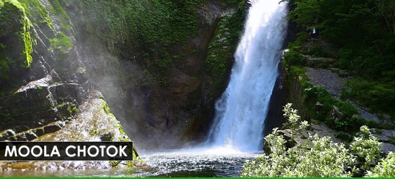
The village of Moola is about 80 kilometers from Khuzdar and is a small valley situated at about 1,237 meters above sea level. It has very beautiful waterfalls which are surrounded by vigorous greenery and tall cliffs. This place is renowned for its massive mountains, textured rocks, bubbling streams, and hot springs which give the visitors a very delightful surprise. Moola Chotok is considered one of the most beautiful places in Balochistan.[/toggle]
[toggle title=”PIR GHAIB” state=”close”]
Pir Ghaib Waterfall of Balochistan is located near the famous Bolan valley. It is around 70 kilometers away from Quetta. Pir Ghaib Waterfalls is a worth-seeing tourist destination which is a magnificent spot in the whole arid zone. Pir Ghaib Waterfalls of Balochistan is basically a cascade waterfall and two separate waterfalls which are flowing into a larger clear and blue pool of cool water. Pir Ghaib Waterfalls of Baluchistan is known to flow in the sterile zones of the Bolan Valley, giving an awe-inspiring view to the tourists.[/toggle]
[toggle title=”PISHIN VALLEY” state=”close”]
Pishin Valley is about 50 kilometers from Quetta city in District Pishin in the northwest of Balochistan province of Pakistan. It consists of thousands of acres of fruit orchards. The valley is a fertile land where several crops and fruits are grown. Pishin Valley is renowned for the greenery and is also the primary place for crop production. Besides the crops it is also famous for the growth of vegetables and fodder. Today Pishin Valley is famous for horticulture and agriculture in Pakistan.
Apart from the fruit, there is a quaint little market town which is famous for eating joints and other traditional foods. There is a man made spring ‘Karez’. This artificial spring is made in order to use the subterranean water for irrigation purposes.
The Pishin Valley is a center of festivity and colorful harvest programs and other cultural fetes. Folk dances are very popular. In spring when most of the plants are in bloom, it gives a splash of colour to Pishin Valley. Migrant tribesmen travel across the valley in autumn and spring with their herds of sheep and camels and their assorted wares for sale. This seasonal movement adds colour and beauty to the life of Pishin Valley.
Folk dances here in the valley are very popular. 1 In spring Pishin Valley gives a picturesque look as most plants are in boom in this season. It is a must visit place as it is a master piece of this world. In the season of autumn and spring migrant tribesmen pass through across this valley along with their herds of sheep and camels and their various products for sale. This seasonal association put in color and prettiness to the life of Pishin Valley.
In recent years Pishin Valley has become one of the important tourist attractions in Balochistan. There lies Bund Khushdil Khan. Bund Khushdil Khan is a 5km long and 2km wide tank and is one of the wonderful sights. It is entirely dependent on rainfall and snow. Today it has become a spot of duck shooting.
In Pishin Valley tourists can participate in activities like horse jumping, trick horse riding, trick motor cycle riding and dare-devil motor car driving. There is also a dog and hare race which is an important event especially during the harvesting festival. There is a fortress nearby and when sun sets the fortress looks splendid. In short Pishin is a full of life and beautiful place to be visited.[/toggle]
[toggle title=”PUNNU FORT” state=”close”]
The ruins of Punnu Fort (also called Punnu’s Fort) are sited about 15km from Turbat, a city in southern part of Balochistan. According to archaeologists Punnu Fort could date back to 6000-8000 BC.
Punnu was a local prince of this area who was port of the “Sassi Punnu” romance which is famous in Makran and Sindh yet, even; thousands of years have been passed. Sassi Punnu (or Sassui Punnhun) love is one the seven popular tragic romances from Sindh and Balochistan.
The fort looks like it would have been small and possibly made of mud and stones. There are vantage points where one could see quite distance accross Turbats plains to the Makran mountain ranges. The remains of Punnu Fort, surrounded by date trees on a high ground can be a good picnic point in a nice weather.[/toggle]
[toggle title=”URRAK FALLS” state=”close”] The Urrak falls are also known as the younger sister to the Hannah Jheel Quetta. It is mentioned together as Hannah Urrak. This place is a fathomable vacation spot for the people of Quetta and around and is also lovable for the food it offers.[/toggle]
[toggle title=”ZIARAT” state=”close”]
Ziarat is a district and a famous hill station located in the north of province of Balochistan. Ziarat is the capital of Ziarat District, Balochistan Province, Pakistan. It is a famous holiday resort of Balochistan. Nearly every trip from Karachi to Quetta stops at Ziarat. Khalifat Hills are the highest peak with an altitude of 11,400 feet in Ziarat district. Ziarat has the highest ‘Human Development Index’ of all districts of Balochistan.
The name Ziarat means ‘Shrine’. There is a shrine of Baba Kharwari 8 km from Ziarat town. His name was Tahir. He became a disciple of Nana Sahib. A number of miracles are attributed to him. A huge number of devotees come here and offer sacrifices. The tribesmen, during the Eid festival gather around the shrine and hold marksmanship and wrestling competitions.About 1 km from Ziarat is the shrine of Baba Nau Gaza. It is surrounded by big graveyards. The real name of Nau Gaza Baba was Kareemdad. It is said that when he died his body became large by nine yards therefore people started to call him Nau(nine) Gaza(yards) Baba. People come to the shrine to pray.
Ziarat is a famous tourist site. Mohammad Ali Jinnah, the founder of Pakistan spent his last days of life in ‘Ziarat Residency’ in Ziarat. It is an important building. The whole building has a wooden structure designed beautifully and has great architectural importance. It was originally meant to be a sanatorium and was converted into the summer residence of the Agent of the Governor General. Now this building is a national monument. The residency catches tourists’ attention due to its unique location.
Ziarat is very famous for its Juniper forest. Zarghoon mount range with a few other mountain ranges of Balochistan is known as the second largest juniper forest in the world. These juniper forests are real wealth of Ziarat. There are several valuable species of animals, birds and plants are discovered in this ecosystem. There are some very old trees in the valley which are more than 5000 to 7000 years old. In winter, when snow falls in Ziarat, the juniper valley becomes the most beautiful place in the world.
The valley is full of fruits in summer and winter, especially the orchards of cherry and apple. The honey of Ziarat is very famous. During summer time the weather is really pleasant but is severe and more difficult to survive in winter.
Balochistan is an arid region and receives very little annual rainfall. But innumerable streams and natural springs known as karez can be found in most parts of the province. There are more than a half dozen gorges around Ziarat formed by karez spring water falling through narrow openings in the mountain rocks, producing a dramatic effect. The gorges along the road to Ziarat are Chutair Tangi, Kahn Tangi, Kawas Tangi, Faran Tangi and Sandman Tangi.[/toggle]
[ads1]
[divider style=”normal” top=”20″ bottom=”20″]
BALOCHISTAN MAJOR CITIES / TOWNS
[tabs type=”vertical”]
[tabs_head]
[tab_title] Khuzdar [/tab_title]
[tab_title] Turbat [/tab_title]
[tab_title] Chaman [/tab_title]
[tab_title] Hub [/tab_title]
[tab_title] Sibi [/tab_title]
[tab_title] Zhob[/tab_title]
[tab_title] Gwadar [/tab_title]
[tab_title] Pasni [/tab_title]
[tab_title] Mastung [/tab_title]
[tab_title] kalat [/tab_title]
[/tabs_head]
[tab]

Khuzdar is the capital city of the Khuzdar District of central Balochistan, Pakistan. Before March 1974, Khuzdar was a section of Kalat District. The Jhalawani or southern dialect of the Brahui language is spoken.
Under a written agreement with Kalat, British appointed a political agent at Khuzdar in 1903.
Read More »
[/tab]
[tab]

Turbat, is a city situated in southern Balochistan, a province of Pakistan. it is located on the left bank of the Kech river, which is a tributary to the Dasht river. The Makran vary to the north and east descends to coastal plains within the south.
Read More »
[/tab]
[tab]

Chaman is the capital of Qilla Abdullah District, Balochistan, Pakistan. it is located south of the Chaman border crossing with neighbouring Spin Boldak in Kandahar Province of Afghanistan.
Chaman has a terminal that accommodates services with Kandahar as well as different parts of Afghanistan.
Read More »
[/tab]
[tab]

Hub is the capital city of the Hub Tehsil, situated within the Lasbela District of Balochistan, Pakistan. Hub is an industrial city and its original name was Hub Chowki because once there was a police and customs check post, named Nakahi.
Read More »
[/tab]
[tab]

Sibi is a town of Balochistan province of Pakistan. The city is the headquarters of the district and tehsil of the same name.
Sibi District is bounded by Mountainous Districts of Ziarat in North, Loralai in North-East, Kohlu in East, Bolan in South and South-West and includes a little border with Mastung district in North-west through Dasht tehsil of Mastung.
Read More »
[/tab]
[tab]

Zhob is a small town and district capital of Zhob District in Balochistan province of Pakistan. Zhob is found on the banks of Zhob river. the city was originally named Appozai after a nearby village. during British colonial era it was named Fort Sandeman. It obtained its current name on thirty July 1976 once the then Prime Minister of Pakistan, Zulfikar Ali Bhutto had the name modified.
Read More »
[/tab]
[tab]

Gwadar city, renowned for the warm water deep sea port of Gwadar, is found on the south-western Arabian Sea shore in coastal area of Balochistan, Pakistan. It is located about 460 kilometers from the city of Karachi and seventy five kilometers from Iranian border. It is the capital of Gwadar District. It additionally works as winter capital for the province of Balochistan.
Read More »
[/tab]
[tab]

Pasni, is a medium-sized town and a fishing port in Gwadar District, Balochistan, Pakistan. it is situated on the Makran coast on Arabian Sea about 450 km from Karachi. Administratively, Pasni is the headquarters of the Pasni sub-division of Gwadar district that includes Pasni and Ormara Tehsils.
Read More »
[/tab]
[tab]

Mastung the capital of Mastung District, is a city within the Balochistan province of Pakistan. The town is additionally the executive centre of Mastung Tehsil, an administrative subdivision of the district – the town itself is administratively divided into 2 Union Councils.
Read More »
[/tab]
[tab]

Kalat or Qalat is a historical town situated in Kalat District, Balochistan, Pakistan. Kalat is the capital of Kalat District and is known regionally as Kalat-e-Brahui and Kalat-e-Sewa.
Qalat, formerly Qilat, is found roughly within the center of Balochistan, Pakistan, it is located in Turbat town of Kech division Balochistan.
Read More »
[/tab]
[/tabs]
[divider style=”normal” top=”20″ bottom=”20″]


